Clarendon County, Yeni Güney Galler - Clarendon County, New South Wales

Şunları kullanarak tüm koordinatları eşleyin: OpenStreetMap  
Koordinatları şu şekilde indirin: KML  · GPX
Clarendon
Yeni Güney Galler
Clarendon NSW.PNG
Arazi idari bölümleri Clarendon çevresinde:
Bourke Mülayim Mülayim
Bourke Clarendon Sertleşmek
Mitchell Wynyard Buccleuch

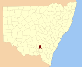
Clarendon County 141 kişiden biri Yeni Güney Galler kadastro bölümleri. Kasabalarını içerir Gundagai, Junee ve Bethungra. Murrumbidgee Nehri güneydeki sınırdır.

Clarendon County onuruna seçildi George William Frederick Villiers 4. Earl Clarendon (1800-1870).[1]

Murrumbidgee Nehri -de Gundagai; Clarendon ve arasındaki sınır Wynyard

Bu ilçedeki mahalleler

Bu ilçede bulunan mahallelerin tam listesi; onların akımı LGA ve her bir konumun yaklaşık merkezine eşleme koordinatları aşağıdaki gibidir:

BucakLGAKoordinatlar
BethungraJunee Shire Konseyi34 ° 43′54″ G 147 ° 50′04 ″ D / 34,73167 ° G 147,83444 ° D / -34.73167; 147.83444 (Bethungra)
BildaJunee Shire Konseyi35 ° 04′54 ″ G 147 ° 39′04 ″ D / 35.08167 ° G 147.65111 ° D / -35.08167; 147.65111 (Bilda)
BillabungJunee Shire Konseyi34 ° 47′54″ G 147 ° 48'04 ″ D / 34.79833 ° G 147.80111 ° D / -34.79833; 147.80111 (Billabung)
BoreeJunee Shire Konseyi34 ° 50′54″ G 147 ° 39′04 ″ D / 34.84833 ° G 147.65111 ° D / -34.84833; 147.65111 (Boree)
BulganWagga Wagga Şehri34 ° 57′54 ″ G 147 ° 20′04 ″ D / 34.96500 ° G 147.33444 ° D / -34.96500; 147.33444 (Bulgan)
ButeJunee Shire Konseyi34 ° 35′54″ G 147 ° 46′04 ″ D / 34.59833 ° G 147.76778 ° D / -34.59833; 147.76778 (Bute)
ClarisJunee Shire Konseyi34 ° 59′54″ G 147 ° 40'04 ″ D / 34.99833 ° G 147.66778 ° D / -34.99833; 147.66778 (Claris)
CoobaJunee Shire Konseyi34 ° 55′54″ G 147 ° 52′04 ″ D / 34.93167 ° G 147.86778 ° D / -34.93167; 147.86778 (Cooba)
EunanoreenyaWagga Wagga Şehri35 ° 03′54 ″ G 147 ° 29′04 ″ D / 35.06500 ° G 147.48444 ° D / -35.06500; 147.48444 (Eunanoreenya)
EurongillyJunee Shire Konseyi34 ° 55′54″ G 147 ° 45'04 ″ D / 34.93167 ° G 147.75111 ° D / -34.93167; 147.75111 (Eurongilly)
GobbagombalinWagga Wagga Şehri35 ° 02′54 ″ G 147 ° 18'04 ″ D / 35.04833 ° G 147.30111 ° D / -35.04833; 147.30111 (Gobbagombalin)
GwynneJunee Shire Konseyi34 ° 47′54″ G 147 ° 30′04 ″ D / 34.79833 ° G 147.50111 ° D / -34.79833; 147.50111 (Gwynne)
HoulaghanJunee Shire Konseyi34 ° 43′40″ G 147 ° 32′43 ″ D / 34.72778 ° G 147.54528 ° D / -34.72778; 147.54528 (Houlaghan)
HurleyJunee Shire Konseyi34 ° 36′54″ G 147 ° 41′04 ″ D / 34.61500 ° G 147.68444 ° D / -34.61500; 147.68444 (Hurley)
IronbongJunee Shire Konseyi34 ° 44′54″ G 147 ° 45'04 ″ D / 34.74833 ° G 147.75111 ° D / -34.74833; 147.75111 (Ironbong)
IvorJunee Shire Konseyi34 ° 44′54″ G 147 ° 40'04 ″ D / 34.74833 ° G 147.66778 ° D / -34.74833; 147.66778 (Ivor)
JeralgambethJunee Shire Konseyi34 ° 59′54 ″ G 147 ° 35'04 ″ D / 34,99833 ° G 147,58444 ° D / -34.99833; 147.58444 (Jeralgambeth)
JuneeJunee Shire Konseyi34 ° 47′54″ G 147 ° 33′04 ″ D / 34.79833 ° G 147.55111 ° D / -34.79833; 147.55111 (Junee)
KimoCootamundra-Gundagai Bölge Konseyi35 ° 02′54 ″ G 148 ° 00′04 ″ D / 35.04833 ° G 148.00111 ° D / -35.04833; 148.00111 (Kimo)
MaleboJunee Shire Konseyi34 ° 55′54″ G 147 ° 23′04 ″ D / 34.93167 ° G 147.38444 ° D / -34.93167; 147.38444 (Malebo)
MarorJunee Shire Konseyi34 ° 50′54″ G 147 ° 28'04 ″ D / 34.84833 ° G 147.46778 ° D / -34.84833; 147.46778 (Maror)
MerrybundinahJunee Shire Konseyi34 ° 51′54 ″ G 147 ° 48'04 ″ D / 34.86500 ° G 147.80111 ° D / -34.86500; 147.80111 (Merrybundinah)
Mitta MittaJunee Shire Konseyi34 ° 51′54 ″ G 147 ° 54'04 ″ D / 34.86500 ° G 147.90111 ° D / -34.86500; 147.90111 (Mitta Mitta)
NangusCootamundra-Gundagai Bölge Konseyi35 ° 00′54 ″ G 147 ° 57'04 ″ D / 35.01500 ° G 147.95111 ° D / -35.01500; 147.95111 (Nangus)
Kuzey GundagaiCootamundra-Gundagai Bölge Konseyi35 ° 00′54 ″ G 148 ° 04′04 ″ D / 35.01500 ° G 148.06778 ° D / -35.01500; 148.06778 (Kuzey Gundagai)
Kuzey Wagga WaggaWagga Wagga Şehri35 ° 03′54 ″ G 147 ° 23′04 ″ D / 35.06500 ° G 147.38444 ° D / -35.06500; 147.38444 (Kuzey Wagga Wagga)
OuraWagga Wagga Şehri35 ° 03′54 ″ G 147 ° 33′04 ″ D / 35.06500 ° G 147.55111 ° D / -35.06500; 147.55111 (Oura)
SebastopolTemora Shire Konseyi34 ° 35′54″ G 147 ° 34'04 ″ D / 34.59833 ° G 147.56778 ° D / -34.59833; 147.56778 (Sebastopol)
Güney JuneeJunee Shire Konseyi34 ° 53′54″ G 147 ° 31′04 ″ D / 34.89833 ° G 147.51778 ° D / -34.89833; 147.51778 (Güney Junee)
TenandraJunee Shire Konseyi34 ° 59′54″ G 147 ° 50′04 ″ D / 34.99833 ° G 147.83444 ° D / -34.99833; 147.83444 (Tenandra)
TrevethinJunee Shire Konseyi34 ° 40′54″ G 147 ° 40'04 ″ D / 34.68167 ° G 147.66778 ° D / -34.68167; 147.66778 (Trevethin)
UlandraJunee Shire Konseyi34 ° 45′54″ G 147 ° 54'04 ″ D / 34.76500 ° G 147.90111 ° D / -34.76500; 147.90111 (Ulandra)
WallaceWagga Wagga Şehri34 ° 57′54 ″ G 147 ° 28'04 ″ D / 34.96500 ° G 147.46778 ° D / -34.96500; 147.46778 (Wallace)
AranıyorJunee Shire Konseyi34 ° 59′54 ″ G 147 ° 45'04 ″ D / 34.99833 ° G 147.75111 ° D / -34.99833; 147.75111 (Aranıyor)
WantioolJunee Shire Konseyi34 ° 54′54″ G 147 ° 39′04 ″ D / 34.91500 ° G 147.65111 ° D / -34.91500; 147.65111 (Wantiool)
Warre WarralJunee Shire Konseyi34 ° 38′54″ G 147 ° 32′04 ″ D / 34.64833 ° G 147.53444 ° D / -34.64833; 147.53444 (Warre Warral)

Referanslar

  1. ^ "Clarendon İlçesi". NSW Coğrafi Adlar Kaydı (GNR). Yeni Güney Galler Coğrafi İsimler Kurulu. Bunu Vikiveri'de düzenleyin