Forehoe ve Henstead Kırsal Bölgesi - Forehoe and Henstead Rural District - Wikipedia
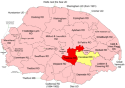 1894'te sınırlar. Forehoe RD kırmızı, Henstead RD sarı. | 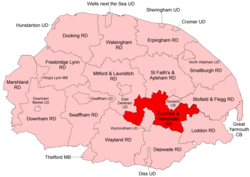 1935'te sınırlar |
Forehoe ve Henstead Kırsal Bölgeleri bitişiktiler kırsal bölgeler içinde Norfolk, İngiltere 1894'ten 1935'e kadar.[1][2]
Altında oluşturuldular Yerel Yönetim Yasası 1894 dayalı kırsal sağlık bölgeleri aynı isimlerden ve genellikle güneyde Norwich.
1935'te Wymondham Forehoe RD cemaati yeni bir Wymondham Kent Bölgesi. Kalan, bir adadan ayrı olarak Henstead RD'nin tamamı ile birlikte Yare Nehri, oluşturmak için birleştirildi Forehoe ve Henstead Kırsal Bölgesi.[3] Daha sonra, 1968'de Norwich County Borough ile sınırda değişiklikler yapıldı.
1974'te, birleştirilmiş bölge, Yerel Yönetim Yasası 1972 ve bir parçası oldu Güney Norfolk ilçe.
İstatistik
| Yıl | Forehoe RD | Henstead RD | ||||
|---|---|---|---|---|---|---|
| Alan (ha) [4] | Nüfus [5] | Yoğunluk (pop / ha) | Alan (ha) [6] | Nüfus [7] | Yoğunluk (pop / ha) | |
| 1911 | 15,592 | 11,383 | 0.73 | 17,151 | 10,285 | 0.60 |
| 1921 | 11,305 | 0.73 | 9,901 | 0.58 | ||
| 1931 | 12,910 | 0.83 | 10,779 | 0.63 | ||
| Forehoe ve Henstead RD[8][9] | ||||||
| 1951 | 28,304 | 23,376 | 0.83 | |||
| 1961 | 25,860 | 0.91 | ||||
Mahalle
Bu cemaatler, aksi belirtilmedikçe Forehoe ve Henstead RD içinde faaliyet göstermektedir.
| Bucak | Nereden | İçin | Notlar |
|---|---|---|---|
| Arminghall | 1935 | Henstead RD. Bixley'e eklendi | |
| Barford | Forehoe RD | ||
| Barnham Süpürgesi | Forehoe RD | ||
| Bawburgh | Forehoe RD | ||
| Bixley | Henstead RD | ||
| Bowthorpe | 1935 | Forehoe RD. Runhall'a eklendi | |
| Bracon Kül | Henstead RD | ||
| Bramerton | Henstead RD | ||
| Brandon Parva | 1935 | Forehoe RD. Runhall'a eklendi | |
| Caistor St Edmund | Henstead RD | ||
| Carleton Forehoe | 1935 | Forehoe RD. Kimberley'ye eklendi | |
| Colney | Henstead RD | ||
| Colton | 1935 | Forehoe RD. Marlingford'a eklendi | |
| Costessey | Forehoe RD | ||
| Coston | 1935 | Forehoe RD. Runhall'a eklendi | |
| Cringleford | Henstead RD | ||
| Crownthorpe | 1935 | Forehoe RD. Wicklewood'a eklendi | |
| Deopham | Forehoe RD | ||
| Dunston | 1935 | Henstead RD. Stoke Holy Cross'a eklendi | |
| Doğu Carleton | Henstead RD | ||
| Easton | Forehoe RD | ||
| Flordon | Henstead RD | ||
| Framingham Earl | Henstead RD | ||
| Framingham Pigot | Henstead RD | ||
| Great Melton | Henstead RD | ||
| Hackford | 1935 | Forehoe RD. Deopham'a eklendi | |
| Hethersett | Henstead RD | ||
| Hingham | Forehoe RD | ||
| Holverston | Henstead RD | ||
| Intwood | 1935 | Henstead RD. Keswick'e eklendi | |
| Keswick | Henstead RD | ||
| Ketteringham | Henstead RD | ||
| Kimberley | Forehoe RD | ||
| Kirby Bedon | Henstead RD | ||
| Küçük Melton | Henstead RD | ||
| Markshall | 1935 | Henstead RD. Caistor St Edmund'a eklendi | |
| Marlingford | Forehoe RD | ||
| Morley | 2 Morley cemaatinin birleşmesi | ||
| Morley St Botolph | 1935 | Forehoe RD. Morley Bileşeni | |
| Morley St Peter | 1935 | Forehoe RD. Morley Bileşeni | |
| Mulbarton | Henstead RD | ||
| Newton Flotman | Henstead RD | ||
| Poringland | Henstead RD | ||
| Rockland St Mary | Henstead RD | ||
| Runhall | Forehoe RD | ||
| Saxlingham Nethergate | Henstead RD | ||
| Saxlingham Thorpe | 1925 | Henstead RD. Saxlingham Nethergate'e eklendi | |
| Shotesham | 1935 | 2 Shotesham cemaatinin birleşmesi | |
| Shotesham All Saints | 1935 | Henstead RD | |
| Shotesham St Mary | 1935 | Henstead RD | |
| Stoke Kutsal Haç | Henstead RD | ||
| Surlingham | Henstead RD | ||
| Swainsthorpe | Henstead RD | ||
| Swardeston | Henstead RD | ||
| Newton ile gezin | Henstead RD | ||
| Welborne | 1935 | Forehoe RD. Runhall'a eklendi | |
| Whitlingham | 1935 | Henstead RD. Kirby Bedon'a Aded | |
| Wicklewood | Forehoe RD | ||
| Wramplingham | Forehoe RD | ||
| Wreningham | Henstead RD | ||
| Wymondham | 1935 | Forehoe RD. Wymondham UD oldu |
Referanslar
- ^ "Zaman içinde RD: Yerel Yönetim Bölgesi verileriyle birlikte sayım tabloları". Zaman İçinde Britanya Vizyonu. GB Tarihi CBS / Portsmouth Üniversitesi. Alındı 1 Temmuz 2017.
- ^ "Zaman içinde Henstead RD: Yerel Yönetim Bölgesi verileriyle birlikte nüfus sayımı tabloları". Zaman İçinde Britanya Vizyonu. GB Tarihi CBS / Portsmouth Üniversitesi. Alındı 1 Temmuz 2017.
- ^ "Forehoe ve Henstead RD zaman içinde: Yerel Yönetim Bölgesi verileriyle birlikte nüfus sayımı tabloları". Zaman İçinde Britanya Vizyonu. GB Tarihi CBS / Portsmouth Üniversitesi. Alındı 1 Temmuz 2017.
- ^ "Forehoe RD zaman içinde: Nüfus İstatistikleri: Alan (dönüm)". Zaman İçinde Britanya Vizyonu. GB Tarihi CBS / Portsmouth Üniversitesi. Alındı 1 Temmuz 2017.
- ^ "Forehoe RD zaman içinde: Nüfus İstatistikleri: Toplam Nüfus". Zaman İçinde Britanya Vizyonu. GB Tarihi CBS / Portsmouth Üniversitesi. Alındı 1 Temmuz 2017.
- ^ "Zaman içinde Henstead RD: Nüfus İstatistikleri: Alan (dönüm)". Zaman İçinde Britanya Vizyonu. GB Tarihi CBS / Portsmouth Üniversitesi. Alındı 1 Temmuz 2017.
- ^ "Zaman içinde Henstead RD: Nüfus İstatistikleri: Toplam Nüfus". Zaman İçinde Britanya Vizyonu. GB Tarihi CBS / Portsmouth Üniversitesi. Alındı 1 Temmuz 2017.
- ^ "Forehoe ve Henstead RD zaman içinde: Nüfus İstatistikleri: Alan (dönüm)". Zaman İçinde Britanya Vizyonu. GB Tarihi CBS / Portsmouth Üniversitesi. Alındı 1 Temmuz 2017.
- ^ "Forehoe ve Henstead RD zaman içinde: Nüfus İstatistikleri: Toplam Nüfus". Zaman İçinde Britanya Vizyonu. GB Tarihi CBS / Portsmouth Üniversitesi. Alındı 1 Temmuz 2017.